 Many people would cycle more, whether it is for exercise and leisure, or to go about their daily life if they felt safer on the routes available.
It would take years to reconstruct our cities to make them as cycle friendly as Holland, if ever we did, but meanwhile we can find best routes already there.
Most towns and settlements grew up along roads so we have a 'Main Street' or a cross roads with 'North Street, South Street, East Street and West Street' as in Havant.
To get about we just walked down the road a bit, but as communities grew we needed to get from one quarter to another, and of course to neighbouring communities.
If you look at any map you will see our countryside carved up by rivers and railways which focus traffic to bridges and other crossing points, leaving only one way to go, and the risk of conflict points.
High speed roads and Motorways have added to this.
Our modern transport system focusses on better roads capable of carrying a lot of traffic , so Buses and cars mainly use the faster roads which become busier.
If you ride on a bus you may think 'I wouldn't want to ride a bike along here' but there are many other roads available.
Ideally we'd each like to find a straight road with not too many hills going directly from where we are to where we want to be, but that just isn't going to happen, is it?
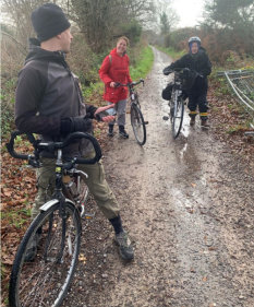
Solent Cycle Project is a group that is helping people to find the safest cycle routes to get around the borough and they are running some 'Bike the Borough' events from March which will be open to people who are not confident at cycling. They have already surprised themselves with a few useful routes.
One of the most obvious and familiar is the disused railway line from Havant Station in the town centre to Hayling Island: The Hayling Billy line. This has been converted from a disused track to a usable road for cyclists and pedestrians, and on Hayling for Horse riders.
Not only does it go from centre to centre, but it passes under the main road (East Street) but you still have to cross the busy road from the roundabout at Langstone, although there is a pedestrian crossing and the Lights on the roundabout interrupt the motorised traffic.
Less well known to many is Park Lane which runs from Middle Park and crosses the A3(M). This route is a bit overgrown but could easily be tidied up and is quite rideable as it is.
This area is noted for its many streams flowing from the Downs to the sea, and some of these have good tracks beside them. An example runs from New Road Havant, near the college, runs North, parallel to Stockheath lane then meanders its way North to Middle Park Way.
All these routes give access to various locations on the way so they form secondary communication networks for the town with reduced involvement with busy traffic.
We have not yet compiled a list of these routes but readers are invited to submit their favourite so that less confident cyclists can see how practical motorless travel is.